
Time is money – planning security is priceless
Our aviation restriction analysis offers a comprehensive GIS-based review of all relevant aviation restrictions for your planned wind turbines. While official preliminary inquiries often take more than a year, we provide you with clarity on the most important aviation law issues within 24 hours.
Problem
The planning of wind turbines is associated with numerous legal and planning challenges. Aviation restrictions often present unforeseen obstacles that are only recognized late in the project and can lead to costly delays or even the failure of the project.
Typical planning obstacles
Official delays: Lengthy waiting times for official preliminary inquiries (>1 year)
Lack of transparency: Insufficient information on aviation law restrictions
Late risk identification: Reasons for prevention are often only recognized after considerable investment
Waste of resources: Inefficient use of project resources on unrealizable locations
Solution
Our GIS-based analysis examines all relevant aviation restrictions and provides well-founded results for your project planning. With monthly updated data and precise evaluations, we provide clarity on all aviation law issues that are crucial for your wind energy projects.
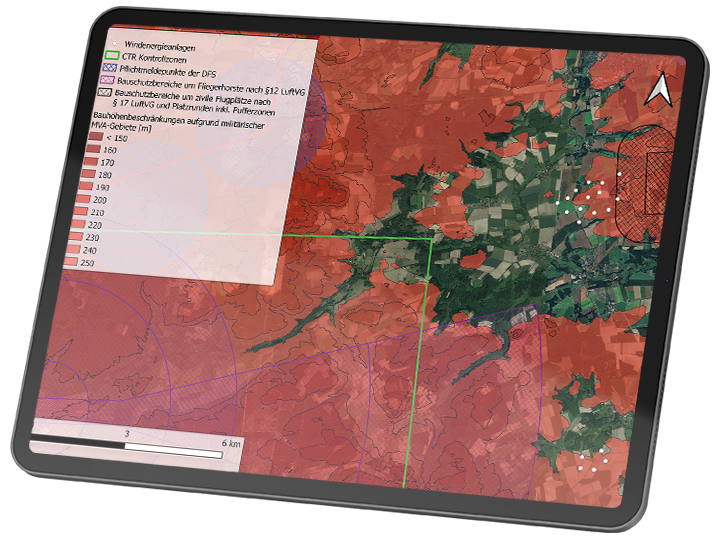
Comprehensive check of all restriction types
Civil aviation: construction protection areas (airports §12 LuftVG, airfields §17 LuftVG), DFS radar systems and mandatory reporting points, MVA areas, DWD facilities (wind profilers, weather radars), airfield areas, controlled traffic regions, instrument landing systems
Military aviation: construction protection areas around air bases, military radar installations, air defense radars, MVA areas (incl. climate correction factor), jet night low-flying system, mandatory reporting points, ED-R low-flying areas, TACAN and other restrictions
Problem
The planning of wind turbines is associated with numerous legal and planning challenges. Aviation restrictions often present unforeseen obstacles that are only recognized late in the project and can lead to costly delays or even the failure of the project.
Typical planning obstacles
Official delays: Lengthy waiting times for official preliminary inquiries (>1 year)
Lack of transparency: Insufficient information on aviation law restrictions
Late risk identification: Reasons for prevention are often only recognized after considerable investment
Waste of resources: Inefficient use of project resources on unrealizable locations
Solution
Our GIS-based analysis examines all relevant aviation restrictions and provides well-founded results for your project planning. With monthly updated data and precise evaluations, we provide clarity on all aviation law issues that are crucial for your wind energy projects.
Comprehensive check of all restriction types
Civil aviation: construction protection areas (airports §12 LuftVG, airfields §17 LuftVG), DFS radar systems and mandatory reporting points, MVA areas, DWD facilities (wind profilers, weather radars), airfield areas, controlled traffic regions, instrument landing systems
Military aviation: construction protection areas around air bases, military radar installations, air defense radars, MVA areas (incl. climate correction factor), jet night low-flying system, mandatory reporting points, ED-R low-flying areas, TACAN and other restrictions
After completing the analysis you will receive:

